Log in
All resources
Create a design
6,143 Free Images of Map Symbols
backs of postcards in curt teich postcard archives
address sides of divided back postcards
postcards published by mid-west map
bibliothèque nationale de france
map of the circle of the rhineland by sanson
map collection of leibniz-institut für länderkunde
paper
postcards of tulsa, oklahoma
atlas des anciens plans de paris by imprimerie nationale, 1880 from bhvp
maps in the library of congress
german renaissance,northern renaissance
ptolemy's 1st asian map
map of ancient assyria by philippe de la rué
old maps of mesopotamia
geographia universalis (1545) in the british museum
german renaissance,northern renaissance
geographia universalis (1545) in the british museum
german renaissance,northern renaissance
geographia universalis (1545) in the british museum
german renaissance,northern renaissance
map of ancient assyria by philippe de la rué
old maps of mesopotamia
arnold van langren map of southwest africa
renaissance
geographia universalis (1545) in the british museum
german renaissance,northern renaissance
black and white portrait drawings of women
prudence crandall
turgot map of paris, kyoto university library – derivative files
abbaye de port-royal de paris
old maps of the london borough of southwark
john rocque's 1746 map of london
historical images of église saint-nicolas-du-chardonnet
map of paris by braun & hogenberg - derivative files
etchings in the rijksmuseum amsterdam
maps in the rijksmuseum amsterdam
map of paris by jouvin de rochefort (boutier 112)
maps of paris by françois de la pointe
maps of the duchy of mantua
guillaume sanson
old submaps of paris 5e arrondissement
turgot map of paris – derivative files
a scroll of tribute by qiu ying
vietnamese people in art
coats of arms of cities in quebec
symbols of trois-rivières
chinese paintings in the honolulu museum of art
paintings by wu changshuo
coats of arms of governorates of the russian empire - geraldika.ru versions
symbols of tver oblast
maps from traité de la police, bibliothèque nationale de france
second map of paris from traité de la police
cour d'assise of palais de justice de rouen
impressionism
1630s maps of new york city
manatus map
self-published work
artesian aquifer
brazilian paintings in the museu antônio parreiras
paintings in the museu antônio parreiras
1800s maps of the world
old maps of the world
brazilian paintings in the museu antônio parreiras
antônio rafael pinto bandeira
symbol
maps
symbols for hydrogeological maps
self-published work
symbols for hydrogeological maps in karstic area
self-published work
backs of postcards in curt teich postcard archives
postcards of tulsa, oklahoma
backs of postcards in curt teich postcard archives
postcards of springfield, illinois
backs of postcards in curt teich postcard archives
postcards of miami, oklahoma
backs of postcards in curt teich postcard archives
postcards of tulsa, oklahoma
backs of postcards in curt teich postcard archives
address sides of divided back postcards
backs of postcards in curt teich postcard archives
postcards of tulsa, oklahoma
backs of postcards in curt teich postcard archives
postcards of tulsa, oklahoma
backs of postcards in curt teich postcard archives
postcards of springfield, illinois
backs of postcards in curt teich postcard archives
postcards of vinita, oklahoma
backs of postcards in curt teich postcard archives
postcards of oklahoma city
backs of postcards in curt teich postcard archives
postcards of tulsa, oklahoma
backs of postcards in curt teich postcard archives
postcards of oklahoma city
backs of postcards in curt teich postcard archives
postcards of claremore, oklahoma
backs of postcards in curt teich postcard archives
postcards of tulsa, oklahoma
backs of postcards in curt teich postcard archives
postcards of miami, oklahoma
a map of the provinces of new york and new jersey, with a part of pennsylvania and the province of quebec
map of the german empire by louis stanislas d'arcy de la rochette
1773 maps of the holy roman empire
the story of the map of europe, its making and its changing (1916)
orientalism
map of paris by jouvin de rochefort (boutier 112)
maps of paris by françois de la pointe
postcards of alaska
map postcards
atlas des anciens plans de paris by imprimerie nationale, 1880 from bhvp
map of paris by françois quesnel
map of maastricht by willem and johannes blaeu (1649)
markt (maastricht)
atlas des anciens plans de paris by imprimerie nationale, 1880 from bhvp
dheulland map of paris
20th-century maps of illinois
curt teich postcard archives
hendrik van langren map of south asia
1590s maps of armenia
maps of the league of nations
1929 maps of the world
1895 sanborn fire insurance map from new orleans, orleans parish, louisiana
maps in the library of congress
map of ancient assyria by philippe de la rué
old maps of mesopotamia
science
etc
maps by thomas kitchin
andrew dury
civitates orbis terrarum. de praecipuis totius universi urbibus. liber secundus
hierosolyma urbs sancta map by braun & hogenberg
map collection of leibniz-institut für länderkunde
maps of spain by tomas lopez
turgot map of paris, kyoto university library – derivative files
foire saint-germain on old maps
map collection of leibniz-institut für länderkunde
maps of spain by tomas lopez
map collection of leibniz-institut für länderkunde
maps of spain by tomas lopez
national museum of maps and rare books, bucharest
maps by abraham ortelius
map of paris by braun & hogenberg - derivative files
rue des archives (paris)
16th-century maps of the indian ocean
renaissance
old maps of montenegro
old maps of dubrovnik
atlas des anciens plans de paris by imprimerie nationale, 1880 from bhvp
turgot map of paris, bibliothèque historique de la ville de paris
atlas des anciens plans de paris by imprimerie nationale, 1880 from bhvp
turgot map of paris, bibliothèque historique de la ville de paris
atlas des anciens plans de paris by imprimerie nationale, 1880 from bhvp
turgot map of paris, bibliothèque historique de la ville de paris
atlas des anciens plans de paris by imprimerie nationale, 1880 from bhvp
turgot map of paris, bibliothèque historique de la ville de paris
map of paris by jouvin de rochefort (boutier 112)
pont de grammont
old maps of the london borough of tower hamlets
maps by john pine
old maps of the tuamotus
old maps of polynesia
a map of the british empire in america with the french and spanish settlements adjacent thereto
maps in the library of congress
a map of the british empire in america with the french and spanish settlements adjacent thereto
maps in the library of congress
a map of the british empire in america with the french and spanish settlements adjacent thereto
maps in the library of congress
a map of the british empire in america with the french and spanish settlements adjacent thereto
maps in the library of congress
a map of the british empire in america with the french and spanish settlements adjacent thereto
maps in the library of congress
self-published work
artesian aquifer
symbols for hydrogeological maps
self-published work
symbols for hydrogeological maps
self-published work
old submaps of paris 1er arrondissement
paris in the 18th century
maps by thomas kitchin
andrew dury
paintings by pieter claesz. soutman
baroque painting
cartes generales de toutes les parties du monde (1658)
1650s maps of saxony
16th-century maps of amsterdam
lodovico guicciardini
john rocque's 1746 map of london
details of old maps of london
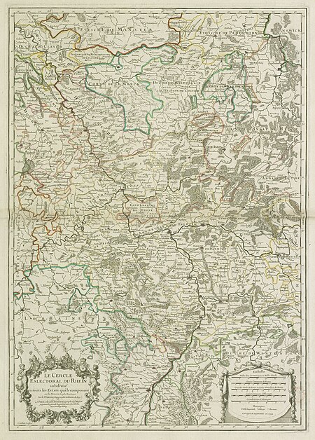
map of the circle of the rhineland by sanson
1670s maps of rhineland-palatinate
map of the circle of the rhineland by sanson
1730s maps of rhineland-palatinate
map of the circle of the rhineland by sanson
1680s maps of rhineland-palatinate
map of the circle of the rhineland by sanson
1730s maps of rhineland-palatinate
map of the circle of the rhineland by sanson
1730s maps of rhineland-palatinate
map of the circle of the rhineland by sanson
1700s maps of rhineland-palatinate
map of the circle of the rhineland by sanson
1700s maps of rhineland-palatinate
map of the circle of the rhineland by sanson
1730s maps of rhineland-palatinate
map of the circle of the rhineland by sanson
1680s maps of rhineland-palatinate
backs of postcards in curt teich postcard archives
postcards of ottawa county, oklahoma
3101 - 3200 of 6,143
Next page
/ 62


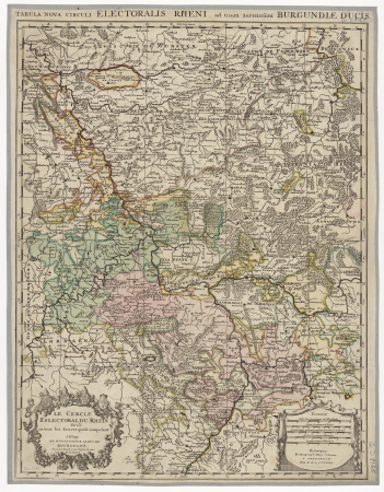
![The Electoral Circle of the Rhine subdivided into all the Estates which compose it... / by Sanson, ,... Geometric Miles or Miles of Italy [30 = 12] common leagues of France, 1734](https://cdn.creazilla.com/illustrations/10001532968/the-electoral-circle-of-the-rhine-subdivided-into-all-the-estates-which-compose-it-by-sanson-geometric-miles-or-miles-of-italy-30-12-common-leagues-of-france-1734-sm.jpg)

